
LuciadCPillar
Centrada en las necesidades del sector de defensa, LuciadCPillar sienta las bases para aplicaciones geoespaciales avanzadas. Los desarrolladores pueden crear aplicaciones de alto rendimiento de comando y control e inteligencia de ubicación gracias al diseño limpio y la estructura modular de la API de LuciadCPillar.
Como API configurable, LuciadCPillar permite integrar componentes de visualización, añadir compatibilidad con datos o bases de datos personalizados, aplicar su propio estilo y simbología de datos, o adaptar la interfaz de usuario a las necesidades y el estilo únicos de su empresa. También puede explorar los datos en una vista de mapa 2D o 3D.
Por qué elegir LuciadCPillar:
- Desarrolle soluciones de escritorio críticas en C++ o C# que gestionen datos geoespaciales con la precisión necesaria para la planificación de misiones.
- Trabaje con formatos estandarizados de simbología de defensa, como MS2525 y APP-6.
- Visualice datos dinámicos en tiempo real, como vuelos, embarcaciones o personas, con decenas de miles de activos en movimiento.
- Gestione diferentes datos y mapas en distintas proyecciones, en 2D y 3D.
- Desarrolle aplicaciones Android táctiles para el conocimiento de la situación sobre el terreno, incluso en entornos desconectados.
- Prepare los datos de su misión y transfiera paquetes de datos a dispositivos Android.
Support for Android devices
Develop mobile applications in Kotlin or Java and benefit from all available LuciadCPillar features.
Use the same code for 2D and 3D visualization with a simple map configuration that can easily be switched. LuciadCPillar automatically drapes any data, with any style, in 3D to follow the terrain.
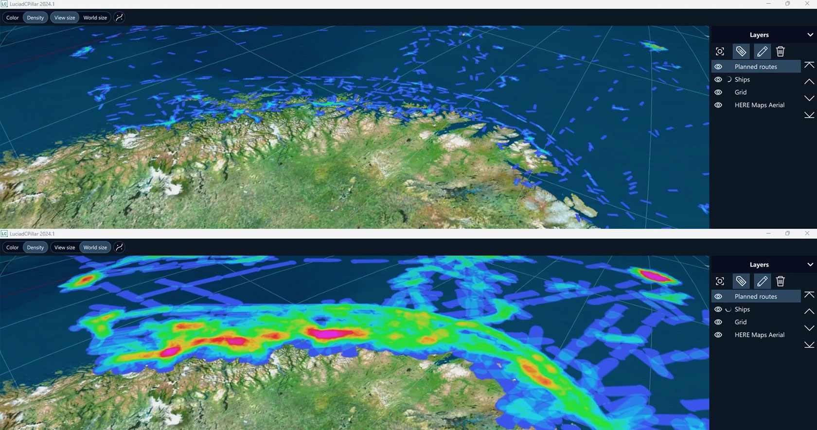
Visualize and update a high number of tracks in real time or simulate in fast time based on a recording. LuciadCPillar is specifically suited for the creation of common operating and recognized air pictures.
Out-of-the-box defense symbology
Search for and create 2D and 3D military symbols. LuciadCPillar supports the latest standards and formats, including APP-6A, APP-6B, APP-6C, APP-6D, MS2525b, MS2525c and MS2525d.
Explore the world at sub-cm accuracy with highly accurate 3D reality meshes and point clouds.